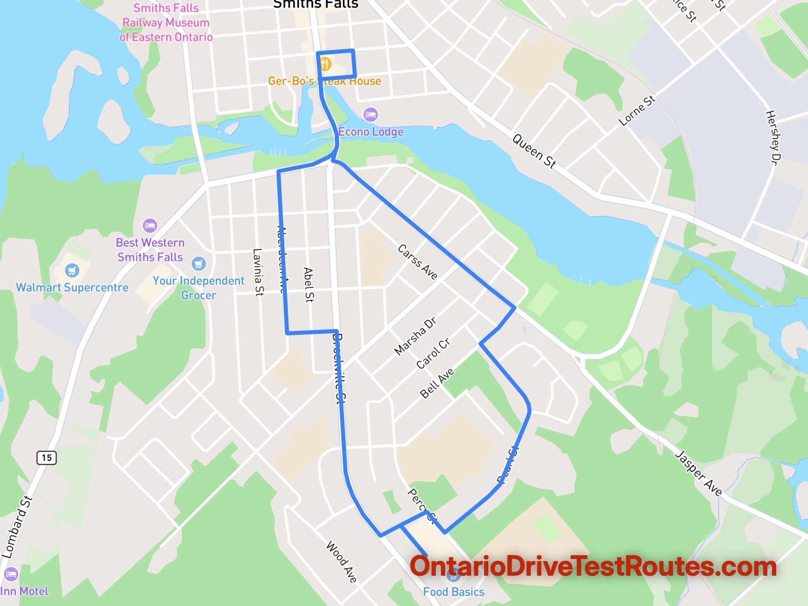
Smiths Falls Test Route Map
14 mins
Route Duration
5.45 km
Route Length
Smiths Falls
Location
Turn-by-Turn Directions
| # | Instruction | Distance | Duration |
|---|---|---|---|
| 1 | Drive northwest. | 0.15 km | 1 min |
| 2 | Turn right onto Toulon Street. | 0.11 km | 1 min |
| 3 | Turn right onto Percy Street. | 0.10 km | 1 min |
| 4 | Turn left onto Pearl Street. | 0.02 km | 1 min |
| 5 | Drive northeast on Pearl Street. | 0.45 km | 1 min |
| 6 | Drive north on Pearl Street. | 0.42 km | 1 min |
| 7 | Turn right onto Vincent Street. | 0.02 km | 1 min |
| 8 | Drive northeast on Vincent Street. | 0.16 km | 1 min |
| 9 | Turn left onto Jasper Avenue. | 0.06 km | 1 min |
| 10 | Drive northwest on Jasper Avenue. | 0.82 km | 1 min |
| 11 | Turn right onto Beckwith Street South/15. | 0.42 km | 1 min |
| 12 | Turn right onto Main Street East. | 0.13 km | 1 min |
| 13 | Turn right onto Market Street South. | 0.10 km | 1 min |
| 14 | Turn right onto Chambers Street. | 0.13 km | 1 min |
| 15 | Turn left onto Beckwith Street South/15. | 0.27 km | 1 min |
| 16 | Bear right. | 0.11 km | 1 min |
| 17 | Drive southwest. | 0.00 km | 1 min |
| 18 | Bear right onto Lombard Street/15. | 0.13 km | 1 min |
| 19 | Turn left onto Aberdeen Avenue. | 0.33 km | 1 min |
| 20 | Drive south on Aberdeen Avenue. | 0.28 km | 1 min |
| 21 | Turn left onto Jessie Street. | 0.04 km | 1 min |
| 22 | Drive east on Jessie Street. | 0.15 km | 1 min |
| 23 | Turn right onto Brockville Street. | 0.70 km | 1 min |
| 24 | Drive southeast on Brockville Street. | 0.11 km | 1 min |
| 25 | Turn left onto Toulon Street. | 0.09 km | 1 min |
| 26 | Turn right. | 0.15 km | 1 min |
| 27 | Your destination is on the left. | 0.00 km | 1 min |
Disclaimer: This sample route is for demonstration purposes only and does not represent the actual test routes used during the test. Accurate Smiths Falls driver test routes are available with your purchase.
Smiths Falls DriveTest Centre
Address
Smiths Falls DriveTest
County Fair Mall
283 Brockville St
Smiths Falls
ON K7A 4Z6
Phone: 1-888-570-6110
Opening Hours
- Monday: 8:30 AM – 5:00 PM
- Tuesday: 8:30 AM – 5:00 PM
- Wednesday: Closed
- Thursday: 8:30 AM – 5:00 PM
- Friday: 8:30 AM – 5:00 PM
- Saturday: Closed
- Sunday: Closed
Tests Offered
Public: G2 | G | M2 | M | LM2 | LM
Commercial: A | B | C | D | E | F | Z
Pass Rates:
G Test: 67%
G2 Test: 63%
Other Ontario Drive Test Centres
- Arnprior DriveTest
- Bancroft DriveTest
- Barrie DriveTest
- Belleville DriveTest
- Brampton DriveTest
- Brantford DriveTest
- Brockville DriveTest
- Burlington DriveTest
- Chatham DriveTest
- Clinton DriveTest
- Cornwall DriveTest
- Downsview DriveTest
- Dryden DriveTest
- Espanola DriveTest
- Etobicoke DriveTest
- Fort Frances DriveTest
- Guelph DriveTest
- Hamilton DriveTest
- Hawkesbury DriveTest
- Huntsville DriveTest
- Kapuskasing DriveTest
- Kenora DriveTest
- Kingston DriveTest DriveTest
- Kirkland Lake DriveTest
- Kitchener DriveTest DriveTest
- Lindsay DriveTest
- London DriveTest
- Mississauga DriveTest
- New Liskeard DriveTest
- Newmarket DriveTest
- North Bay DriveTest
- Oakville DriveTest
- Orangeville DriveTest
- Orillia DriveTest
- Oshawa DriveTest
- Ottawa Canotek DriveTest
- Ottawa Walkley DriveTest
- Owen Sound DriveTest
- Peterborough DriveTest
- Renfrew DriveTest
- Sarnia DriveTest
- Simcoe DriveTest
- St. Catharines DriveTest
- Stratford DriveTest
- Sudbury DriveTest
- Thunder Bay DriveTest
- Tillsonburg DriveTest
- Timmins DriveTest
- Toronto Metro East DriveTest
- Toronto Port Union DriveTest
- Walkerton DriveTest
- Winchester DriveTest
- Windsor DriveTest
- Woodstock DriveTest
Drive Testing in Smiths Falls, Ontario
Smiths Falls is a small city of approximately 8,500 people located in Lanark County in Eastern Ontario, roughly midway between Ottawa and Kingston along Highway 29. Situated on the Rideau River and with strong heritage as a railway centre, Smiths Falls serves as a regional hub for Lanark County and surrounding communities. The DriveTest Centre on Brockville Street (in the County Fair Mall) serves candidates from Smiths Falls and the broader Lanark area including Perth, Jasper, and rural Lanark communities.
The driving environment is decidedly small-town, with straightforward roads and modest traffic — making Smiths Falls a relatively low-pressure test environment compared to urban centres.
What to Expect at Smiths Falls DriveTest
The DriveTest Centre is located in the County Fair Mall area on Brockville Street, Smiths Falls’ main downtown commercial thoroughfare. Test routes typically include Brockville Street’s sections, surrounding residential neighbourhoods, and potentially some access to the Rideau River area or nearby county roads. With an average duration of just 9.12 minutes covering 6.23 kilometres, the Smiths Falls route is notably one of the shortest in Ontario — reflecting the small town’s compact geography.
Pass Rates at Smiths Falls DriveTest
Smiths Falls’ pass rates are near the provincial average:
- G Test pass rate: 67% — below the provincial norm of around 70%
- G2 Test pass rate: 63% — also below the provincial average
These figures suggest Smiths Falls presents a moderately challenging test environment. For comparison:
- Sarnia: G 77%, G2 76%
- Belleville: G 80%, G2 78%
- Renfrew: G 70%, G2 58%
- Brockville: G rates not published, G2 comparable
The pass rates are honest and fair — not exceptionally easy, but achievable with good preparation.
Smiths Falls’ Road Environment
Brockville Street and Downtown
Brockville Street is Smiths Falls’ main street, running through the downtown with retail and service businesses. It features standard two-lane town traffic patterns, signal lights at key intersections, and moderate traffic volumes.
Residential Neighbourhoods
Smiths Falls’ residential streets feature small-town characteristics — 40–50 km/h limits, stop signs, and typical residential spacing. These quieter streets form much of the test route.
Rideau River Area
Smiths Falls’ proximity to the Rideau River means some roads near water features, slightly elevated terrain, and scenic areas. Routes may access these riverside roads.
Highway Access
For G tests, Highway 29 or Highway 7 provide regional highway access for the full G licence’s highway driving component.
Preparation Tips for Smiths Falls
-
Know Brockville Street well. This main commercial street is the core of your test route. Practice in both directions, noting signal timing and traffic patterns.
-
Residential neighbourhood confidence. Much of the route includes quiet residential streets. Practice smooth, controlled driving with proper speed management.
-
Rideau River area familiarity. If routes access riverside areas, practice on these roads — their slightly elevated positions and occasional curves require attention.
-
Highway 29 or 7 practice. For G tests, practice entering, cruising at speed, and exiting regional highways safely.
-
Use the compact route to your advantage. At only 6.23 kilometres, this is one of Ontario’s shortest routes. The brevity means every skill is assessed closely — precise, controlled driving throughout is important.
Ontario’s Graduated Licensing System in Smiths Falls
G2 Test in Smiths Falls
The G2 test at 63% pass rate reflects a fair but genuine assessment. All fundamental driving skills are evaluated on Smiths Falls’ small-town roads and residential streets.
Full G Test in Smiths Falls
The G test at 67% is slightly more challenging, suggesting that the highway component and broader skill assessment required for full licencing raises the difficulty bar slightly.
Recommendation
Smiths Falls is a suitable choice for residents of Lanark County and surrounding areas. With pass rates near the provincial average, it offers a fair test environment that’s neither exceptionally easy nor exceptionally challenging. The very compact route length (6.23 km) is distinctive and means close assessment of every skill. Prepare well on Brockville Street and in residential neighbourhoods, and you’ll be ready for success at Smiths Falls.